RadSat HD Pro
- 4.2
- Rating
- 100.00K
- Installs
- Free
- Price
 Analysis by App-foxy
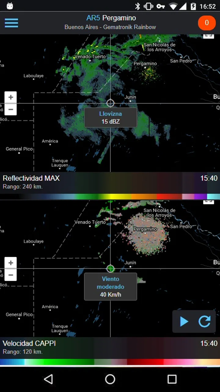
Weather apps usually become useful at the exact moment you are in a hurry: before leaving for work, while planning a drive, or when dark clouds appear over an outdoor event. I found RadSat HD Pro most interesting in those situations because it is built around maps rather than a simple temperature panel. Its focus is weather radar, satellite imagery, and lightning activity, giving me a more visual way to judge what may be approaching. It feels aimed at people who want to inspect the sky around them instead of checking only a short sentence such as “rain later.”
Developed by SocialEx Aplicaciones, this free weather app has reached over a hundred thousand installs and holds a 4.2 average from around two and a half thousand ratings. Those figures suggest a reasonably established audience without making the app feel like an anonymous experiment. It is rated for Everyone, so the presentation is accessible, although the map-based approach may still be more appealing to weather-aware users than to someone who wants the simplest possible forecast.
My overall impression is that the app’s value depends on how often you need visual weather context. If you regularly watch storm movement, compare cloud cover with radar returns, or want to see lightning activity near a route, it offers a more informative workflow than many ordinary forecast apps. If your only question is whether to carry an umbrella, a conventional weather app may be faster to understand.
You May Also Like

 Blood Strike: 2.5 Anniversary
Blood Strike’s Loadouts Turn Every Drop Into a Tactical Gamble
A close look at Blood Strike’s custom loadouts: how fast access to signature weapons reshapes its battle royale rhythm, rewards preparation, and narrows the gap between fights.

 Pandora - Music & Podcasts
Pandora’s Music Is Easy to Start, but Harder to Recover
Pandora’s strength is its low-effort path from a seed to a station. Its weak spot is how much confidence it asks you to place in connection, setup, and quiet recovery.

 8 Ball Pool
 Is Built on Rivalries, Rematches, and Routine
A close look at the rivalries, rematches, shared routines, and unanswered safety questions that turn a quick pool match into a persistent mobile community.

 Samsung Music
’s Quiet Strength Is Playing What You Already Own
Its reach comes less from spectacle than from dependable access to a personal library. That simplicity is both the app’s strongest retention engine and its ceiling.

 AccuWeather: Weather Radar
AccuWeather Review: A Quick, Clear Forecast for Everyday Decisions
For everyday plans, the best forecast is the one you can understand quickly. AccuWeather makes rain timing, radar, and local conditions easy to act on, with a few trade-offs.

 Hill Climb Racing
Why Hill Climb Racing Still Turns Crashes Into One More Run
A tiny car, a bumpy hill and one more upgrade: Hill Climb Racing keeps resurfacing because its simple chaos makes every near-miss feel personal.
More From Our News Desk



How the map experience affects everyday speed
The first thing I noticed is that RadSat HD Pro asks me to look at weather as a moving picture. That changes the meaning of “fast.” A basic forecast can answer a question immediately with a temperature and an icon. A radar map takes a little more attention, but it can answer a more useful question: is the rain already moving toward my area, or is the sky merely cloudy?
On a compatible device, the interface should feel most responsive when I use it for a quick local check rather than repeatedly exploring a large region. The app’s current version is 4.0.17, and that gives the experience a more mature feel than an untouched early release. Still, map-based weather naturally involves more visual content than a text forecast, so I would not judge it by the same standard as a lightweight widget.
The practical speed advantage is decision-making, not just opening time. When I am leaving home, I can look at the radar view and immediately see whether precipitation is close, scattered, or forming farther away. That can be more useful than reading a percentage that does not explain where the rain is or how quickly it may arrive.
The satellite layer adds another perspective. Radar helps me think about precipitation, while satellite imagery gives a broader sense of cloud movement and coverage. I would not treat either view as a guarantee of exactly what will happen over one street, but together they make the app better suited to short-term observation than a standard daily forecast screen.
What happens during a quick morning check
A realistic use case is a morning commute by bicycle. Instead of checking only the hourly forecast, I can open the map, locate my area, and inspect whether a rain band sits directly along the route. If the main activity is still some distance away, I may decide to leave earlier. If the map shows a larger system moving across the route, I have a stronger reason to choose public transport.
This workflow is also useful for parents deciding whether children can play outside, photographers watching cloud conditions, and anyone organizing a short outdoor activity. The benefit is not that the app predicts every detail perfectly; it is that the map gives me context that a single weather icon cannot provide.
Heavy map use and the moments that demand more attention
RadSat HD Pro becomes more demanding when I move beyond a quick local glance. Switching between radar, satellite, and lightning views means I am asking the app to present several layers of changing information. Zooming out for a regional picture can also make the screen busier, especially when multiple weather systems appear at once.
That extra detail is valuable, but it creates a trade-off. A crowded map can slow down my understanding even when the app itself feels responsive. I need to pause and read the visual pattern instead of tapping once and accepting a simple recommendation. For this reason, I prefer using the broad view first and then zooming into the area that matters. Starting too close can make me miss the larger direction of movement.
The lightning layer is particularly useful when I am evaluating outdoor risk, but it should not be treated as a complete safety service. Seeing lightning activity near a planned location is a clear reason to reconsider an event. Not seeing strikes on the screen should not become permission to ignore changing conditions. I see this layer as an additional warning signal, not as a replacement for local official alerts.
During extended use, the main burden is likely to come from keeping a detailed map open rather than from the basic act of checking a forecast. I would avoid leaving the app open unnecessarily while doing unrelated tasks. A short inspection, followed by closing it, is a more sensible habit than treating the map as a constantly running dashboard.
A better workflow for storm watching
For storm tracking, I would use the app in stages. First, I would check the satellite view to understand the broad cloud pattern. Then I would move to radar to see where precipitation is actually concentrated. Finally, I would inspect lightning activity if thunderstorms are a concern. This order reduces confusion because each layer answers a different question.
Another useful habit is to compare the map with what I can see outside. If the screen suggests activity nearby but the sky looks calm, I would not assume one observation is automatically wrong. Weather maps represent a wider area and may not match conditions at my exact position. The app is strongest when I use it to build situational awareness, not when I demand street-level certainty from a regional visualization.
This layered workflow is one of the app’s less obvious strengths. A generic weather app often encourages me to read one forecast card. RadSat HD Pro encourages investigation. That is more work, but it also makes the result more understandable when conditions are changing quickly.
Reliability, recovery, and how much trust to place in the display
For me, reliability in a weather radar app has two parts: whether it remains usable, and whether I interpret its information responsibly. The app’s long presence since its release in March 2017 and its current version indicate an ongoing product rather than a one-off map experiment. That is reassuring when I want a tool I can return to over time.
Even so, a weather map is not the same thing as a guarantee. I would use RadSat HD Pro to observe patterns and support a decision, while checking official emergency guidance for severe conditions. This matters most with lightning, intense storms, or travel plans where a wrong assumption could have serious consequences. The app can improve awareness, but it should not be the only source used for safety-critical choices.
Recovery is also part of the experience. If the map view becomes confusing or does not immediately show what I need, my first response would be to return to the local area, choose one layer, and inspect it before adding more information. That simple reset is more effective than rapidly switching between every available view. It keeps the screen readable and makes it easier to tell whether the issue is the display or my interpretation.
I also appreciate that the app is free to start with. That lowers the barrier for someone who wants to test whether radar-based weather is genuinely useful in daily life. There are in-app purchases listed at $7.99 per item, so I would spend time with the free experience before paying for anything. The right question is not whether an upgrade sounds attractive, but whether the extra value fits the way I actually use weather maps.
Where reliability matters most
If I were planning a hike, a long drive, or an outdoor gathering, I would check the app shortly before leaving and again during the journey when practical. A single check can become outdated as weather systems move. The radar and satellite views are most useful as part of a repeated observation habit, not as a one-time promise about the entire day.
For ordinary errands, that level of caution may be unnecessary. A quick glance is enough to decide whether I want a jacket or an umbrella. For an event with many people, I would combine the map with local forecasts and official warnings. This distinction helps prevent both overconfidence and unnecessary worry.
Device constraints and who will feel them first
The minimum operating-system requirement is Android 3.0, which makes the app broadly approachable from a software-compatibility perspective. However, compatibility alone does not tell me how comfortable the map will feel on every device. Screen size, display clarity, available memory, and general age of the phone can all affect how pleasant it is to examine several visual layers.
On a smaller screen, the map may require more zooming and panning before I can distinguish local details from regional patterns. That is not a flaw unique to this app, but it matters more here because the map is the central experience. Someone using an older or compact phone should expect the visual interface to demand more concentration than a simple list of forecast times.
Resource demands are also tied to usage style. A brief check should be easier to manage than keeping animated or changing weather information visible for a long period. I would use the app deliberately: open it, inspect the relevant layer, make a decision, and close it. That approach is sensible for battery-conscious users and also prevents information overload.
People with limited data plans should think about how often they refresh map information, especially when traveling. I would prepare by checking conditions before leaving and avoid repeatedly reloading the map without a clear reason. The app is more valuable when I use it to answer a specific question than when I leave it running as background scenery.
There is also a learning curve. A person unfamiliar with radar may mistake colors or patterns for a precise forecast without understanding what the display represents. I would recommend beginning with one layer and a familiar location. Once the basic movement makes sense, adding satellite and lightning views becomes much easier.
When another weather app is the better choice
I would choose a conventional forecast app instead when I need a quick glance at today’s temperature, a simple hourly outlook, or a minimal home-screen experience. Those tools are usually easier for routine planning because they reduce the amount of interpretation required. RadSat HD Pro is not the best fit for someone who dislikes maps or wants weather information presented as a few plain sentences.
I would also avoid relying on it alone for official warnings, highly localized emergency instructions, or decisions where conditions can change faster than I can inspect the screen. In those cases, a trusted local authority should take priority. The app can sit alongside that information, but it should not replace it.
Where it wins is visual context. If I want to see whether a rain area is approaching, compare cloud cover with precipitation, or look for nearby lightning activity, it offers a more hands-on experience than a basic forecast utility. That difference is substantial enough to justify installing it for weather enthusiasts, outdoor planners, and commuters who often make decisions around changing skies.
My performance verdict after using it as a practical weather tool
RadSat HD Pro feels best when I treat it as a focused observation tool. Its map-centered design makes it more informative than a standard weather screen for short-term weather awareness, but that benefit comes with extra visual complexity. The app is not trying to make every answer effortless; it gives me layers to inspect and leaves more of the judgment in my hands.
In terms of perceived speed, I would call it efficient for targeted checks and less convenient for casual browsing across large areas. In heavy-use moments, the combination of radar, satellite, and lightning information can make the screen busy, so a disciplined layer-by-layer workflow matters. For stability and recovery, the mature version history and established audience are encouraging, while sensible use still means closing the app when the check is finished and consulting official sources for serious weather.
The free entry point makes it easy to find out whether this style of weather information suits me. The Everyone rating also makes it approachable for general household use, although younger users and casual users may still need a simple explanation of what the map colors and patterns mean. The listed in-app purchases at $7.99 per item are worth considering only after I have confirmed that the core map workflow has a regular place in my routine.
My recommendation is straightforward: install it if you want to understand what weather is doing around you, not merely read a forecast summary. I would especially suggest it to anyone who plans outdoor activities or travels through areas where storms can change plans quickly. I would skip it if my ideal weather app is a quiet widget with one temperature and one rain percentage. For me, RadSat HD Pro earns its place by turning a vague “will it rain?” question into a clearer visual investigation, provided I remember that better information still requires careful judgment.
FAQs for RadSat HD Pro
01What is RadSat HD Pro used for?
RadSat HD Pro is designed for monitoring weather radar information and following precipitation in detail. It can help users observe rain and storm activity, review radar imagery, and understand how weather systems are moving in their area. It is especially useful for people who need more visual weather information than a standard daily forecast provides.
02Does RadSat HD Pro provide real-time weather radar data?
The app is intended to display updated radar imagery, but the availability and refresh speed of data can depend on the selected radar source, geographic coverage, internet connection, and the service provider. Users should remember that radar images may have a short delay and should not be treated as an exact, instant representation of conditions directly above their location.
03Is RadSat HD Pro available for all countries and locations?
Radar coverage is not necessarily identical worldwide. RadSat HD Pro may offer more detailed information in some regions than others, depending on the weather radar networks and data sources available there. Before relying on the app for local monitoring, check whether your country and area are supported and whether the displayed radar has sufficient range and update frequency.
04Does RadSat HD Pro require an internet connection?
Yes, an internet connection is generally necessary to download current radar images, map layers, weather data, and other online information. Mobile data usage may increase when viewing animated radar loops or repeatedly refreshing maps. Some previously loaded content might remain visible temporarily, but users should not expect complete offline access to live weather monitoring.
05Can RadSat HD Pro replace official weather warnings or forecasts?
No. RadSat HD Pro should be considered a supplementary weather-monitoring tool rather than a replacement for official forecasts, emergency alerts, or advice from local authorities. Radar imagery can help users recognize precipitation patterns, but it may not fully explain hazards such as flooding, lightning, strong winds, or rapidly developing storms. Always consult official sources during severe weather.
Pros
- High-resolution radar maps make storm cells easy to track.
- Useful for monitoring rainfall
- snow
- and severe weather nearby.
- Multiple radar layers provide more detailed weather context.
- Clear interface helps users check conditions quickly.
- Pro version offers a more focused
- ad-free viewing experience.
Cons
- Coverage and radar quality depend heavily on your location.
- Some advanced weather data may take time to load.
- Radar imagery can become outdated between update cycles.
- The amount of information may overwhelm first-time users.
- Premium access may feel expensive for occasional weather checks.

RadSat HD Pro
Gallery